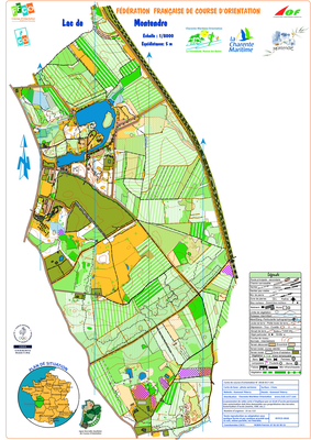


Lac de Montendre
| Numéro : 2018-D17-142 | Carte : 1 |
| Spécialité : CO à pied | Niveau : Départemental |
| Échelle : 1/10000 | Surface : 3,41 km² |
| Cartographes : Gueraud Thierry | |
| Commune la plus proche : Montendre | |
| Parcours permanents : | |
| Nombre de balises : 60 | |
| Propriétaire : 1705 - CHARENTE-MARITIME ORIENTATION | |
| Comment et où obtenir la carte. Responsable à contacter :
- Robin Patrick, 05.4695.68.07, , site web |
|