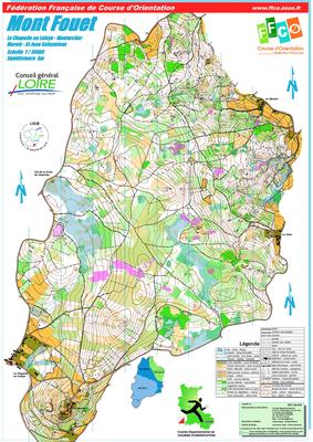


MONT FOUET
| Numéro : 2011-D42-247 | Carte : 1 |
| Spécialité : CO à pied | Niveau : National, International |
| Échelle : 1/10000 | Surface : 6,62 km² |
| Cartographes : BARRANGER David | |
| Commune la plus proche : LA CHAPELLE EN LAFAYE | |
| Parcours permanents : | |
| Nombre de balises : 40 | |
| Propriétaire : 42 - Loire | |
| Comment et où obtenir la carte. Responsable à contacter :
- CDCO 42, 06 75 41 56 36, , site web |
|