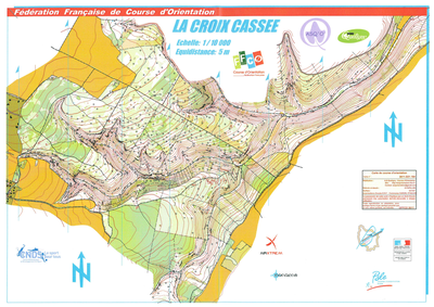


La Croix Cassée
| Numéro : 2011-D21-194 | Carte : 1 |
| Spécialité : CO à pied | Niveau : Régional |
| Échelle : 1/10000 | Surface : 5,53 km² |
| Cartographes : Daniel PAPILLON | |
| Commune la plus proche : Etaules ; Darois | |
| Propriétaire : 2109 - ASSOCIATION SPORTIVE DE QUETIGNY | |
| Comment et où obtenir la carte. Responsable à contacter :
- AS Quetigny, , site web |
|