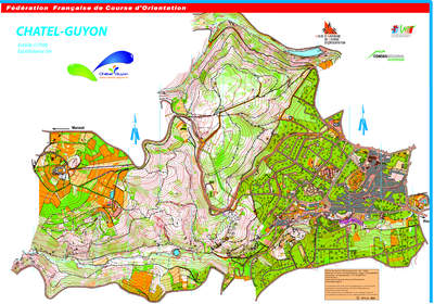


Châtel Guyon
| Numéro : 2001-D63-51 | Carte : 1 |
| Spécialité : CO à pied | Niveau : Régional |
| Échelle : 1/7500 | Surface : 4,06 km² |
| Cartographes : COTIRTA Marian, TAILLEBOIS R | |
| Commune la plus proche : Châtel-Guyon | |
| Parcours permanents : | |
| Nombre de balises : 46 | |
| Propriétaire : AU - Auvergne | |
| Comment et où obtenir la carte. Responsable à contacter :
- Comité Départemental 63, 06 82 31 21 62, - Office de Tourisme, Châtel-Guyon, |
|